Activities in North Staffordshire
North Staffordshire has a wide selection of activities to offer - whether you are looking for an adrenaline filled day, a stag or hen activity or family fun, the following should offer you some choice
The following are details of activity providers in the area, as well as specialists providing experience or training in one activity there are others providing a wide variety from one location – so if you do not find a specialist take a look at the Multi-Activity providers section
Arts & Crafts
Emma Bridgewater Pottery Lichfield Street, Stoke-on-Trent - The decorating studio offers a number of activities and events throughout the year as well as factory tours
Valentine Clays Valentine Way, Fenton - Courses and workshop themed events in a new workshop facility
World of Wedgwood Wedgwood Drive, Barlaston, Stoke-on-Trent - In addition to factory tours, on selected dates, the Decorating Studio offers the chance for both adults and children to get creative with ceramics, paint and glaze also other events such as “Creative Craft Activities” and “Family Friendly Play with Clay” again on selected dates
Airsoft Combat / Paintballing
First and Only Airsoft at Anzio Camp which is a disused M.O.D. barracks and training facility. This site is perfect for everyone from first time players to airsoft veterans as the site and scenarios cater for all types of play.
Ashcroft Park & National Paintball Games – their 2 sites are near Tean and offer a wide variety of activities
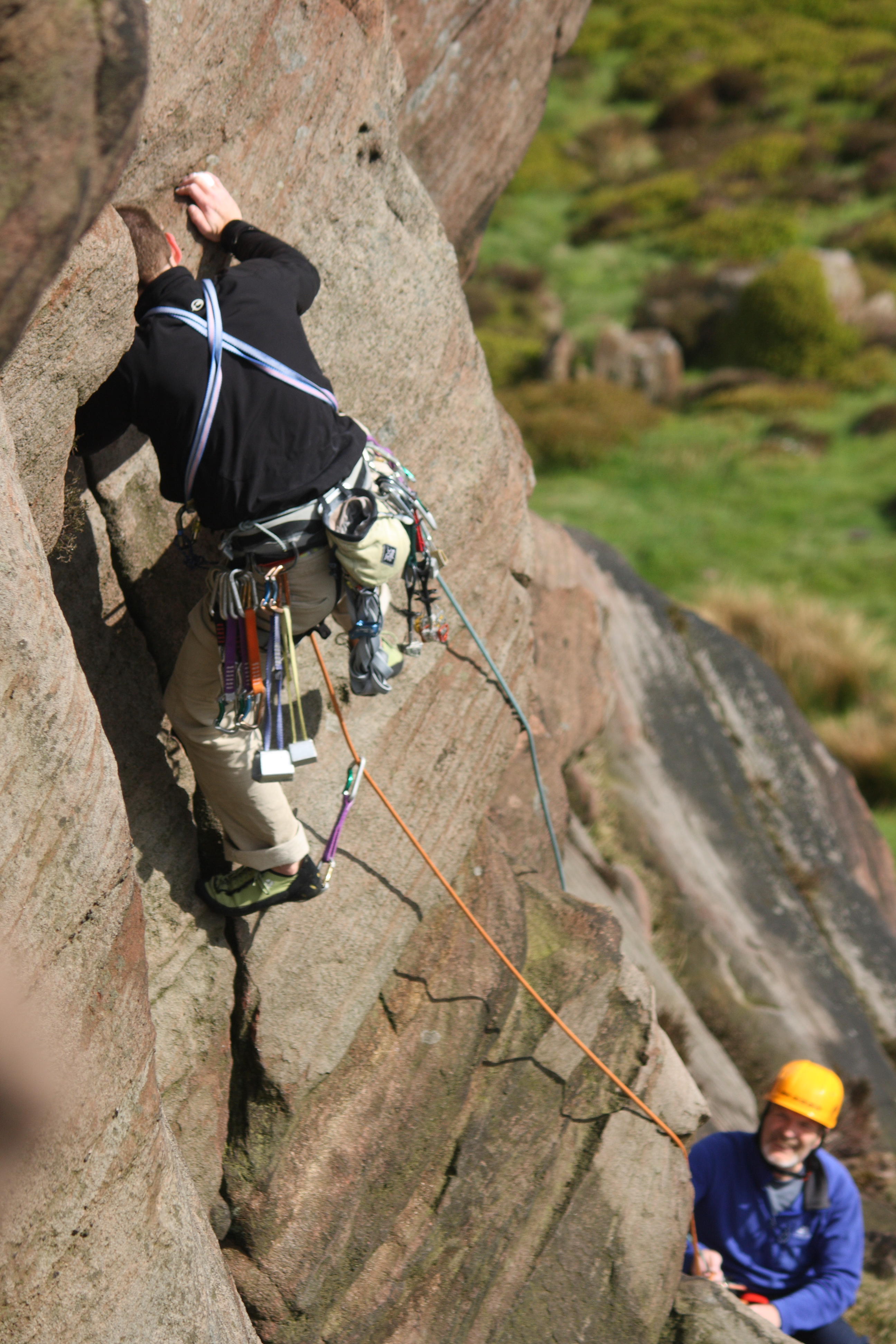
Climbing
Audley Climbing Centre by Peak Pursuits is an indoor centre, packed with routes and challenges for climbers of all ages and abilities
Kilnworx Climbing Centre in Burslem offers great indoor climbs, slabs, angles, overhangs, bridging, corners, arêtes, overhanging arêtes, it's got it all.
Awesome Walls Stoke is England’s largest dedicated bouldering centre. It comprises over 900 square metres of bouldering made up of walls and features of all angles
Jubilee2 Climbing has a bouldering wall,14.5 metre wall with a variety of features,16 routes with grades ranging from 3 to 7a
Clip ‘n Climb Stoke Douglas Park, Opal Way, Stone Business Park
Indoor Climbing - You don't need any previous climbing experience. The standard climbing session is open for 4 years + and there is a Soft Play area for under 4’s
Cycling / Mountain Biking
North Staffordshire has a number of National Cycle Routes traversing it - the 5 / 555 runs North South along the Trent and Mersey Canal, the 550 runs along the Caldon Canal from Etruria as far as Cheddleton and then on across the Staffordshire Moorlands to Waterhouses and the 549 which runs through the Manifold Valley. The 559 leaves the Caldon Canal (550) at Densford (Deep Hayes Country Park) and heads north through Leek on to Meerbrook (Tittesworth Reservoir). In the South of the area route 5 leaves the Trent and Mersey Canal at Aston-by-Stone and takes lanes and roads to Stafford where it joins route 55 which then heads out to Newport and on to Telford. There is also a section of route 55 running from Stoke up to Biddulph and on to Congleton and Cheshire beyond
Roaches and reservoirs cycle rides - 7 and 11 miles - ![]()
There is also a China Cycle Trail aroung the potteries, factory shops and visitor attractions of Stoke on Trent - see ![]()
Family Rides
Biddulph Valley Way – signed as National Cycle Route 55 - This runs for 10 miles between Stoke and Congleton, from the Caldon Canal towpath at Milton to Congleton – it utilised the track bed of the former Biddulph Valley railway line – download a map from our archive
![]()
Biddulph to Whitemore – Old railway line this section is 4.5 miles long with surfaced trail Start at the Old Station Car Park off Smokies Way Biddulph - Whitemore Local Nature Reserve at the northern end – though the trail continues to Congleton see
www.staffsmoorlands.gov.uk/article/844/Biddulph-Valley-Way
Manifold Track – Manifold Valley, Hulme End, Near Hartington – 9 miles from Waterhouses to Hulme End it follows the route of the disused Leek and Manifold Light Railway, the track is surfaced and fairly level throughout its length with most being off-road or on quiet lanes – Bike Hire and Tea Shops - download a map ![]()
Oakamoor (car park) – take the cycle path along the Alton Valley at the 1st Stone Bridge exit cross the bridge and the path brings you to Dimmingsdale (see above) or continue and exit after the old station taking the road to the right up to Alton Village (left and its Alton Towers) and return the same way or take Red Road, the lane past the Dimmingsdale car park, back to Oakamoor
Stafford to Newport Greenway - About 12 miles long, this old railway trackbed is now a surfaced trail between Castlefields in Stafford and Audley Avenue Newport. It forms part of The Way for the Millennium and NCR 55
see
www.staffordshire.gov.uk/... and .../familyfriendlycycling/stafford-greenway
Traffic Free National Cycle Routes
Stone to Stoke via Trent and Mersey Canal Towpath - Signed as NCR 5, passing through Stone, Barlaston, Trentham and Stoke
Stoke to the Harecastle Tunnel From Stoke the Trent Mersey Canal Towpath becomes NCR 555 and passes through Etruria (Junction with the Caldon Canal and Etruria Industrial Museum), Festival Park Marina, Middleport (Middleport Pottery), Westport Lake (Nature Reserve) and on to the Harecastle Tunnel
Hanley Park to Cheddleton Station - National Cycle Route 550 runs from Hanley Park along the Caldon Canal Towpath to Cheddleton Station (Churnet Valley Railway) – passing through Endon, Endon Canal Junction, Denton (Deep Hayes Country Park) Cheddleton (Flint Mill Museum) and on to Cheddleton Station (Heritage Railway)– the 550 then continues on quiet lanes to Waterhouses where it meets the NCR 549 Manifold Valley Way
(a detoure here is possible from the Endon Canal Maintenance Yard, via Park Lane cross the main road to Hallwater Lane, Gratton Lane to Graton and on to Rudyard Lake)
Denford to Leek / Meerbrook NCR 559 – Leaving the Caldon Canal NCR 550 at Denford taking Denford Road and joining the towpath of the Caldon Canal Leek Branch to Barnfeild Road, Leek – the 559 then utilises suburban streets and country lanes continue to Meerbrook (Tittesworth Reservoir and The Roaches)
The Biddulph Greenway signed NCR 55 it runs from Birches Head Road, Milton (just off the Trent and Mersey Canal Towpath see NCR550) and Congleton passing Ford Green Hall, Whitfield Valley Nature Reserve and the Whitfield Valley Heritage Country Park, Biddulph (a small diversion via Marshgreen Road and Congletong Road will take you to Biddulph Grange Gardens (NT) and the Adjoining Biddulph Grange Country Park) or continue on NCR 55 through Whitemoor Nature Reserve and on to Congleton
Stafford to Newport Greenway NCR 55, it forms part of The Way for the Millennium, about 12 miles long, this old railway trackbed is now a surfaced trail, from Castlefields in Stafford to Audley Avenue Newport (Aqualate Mere National Nature Reserve can be reached by leaving the track and taking country lanes)
Bike Hire
Churnet Valley Cycle Hire – Manor House Farm, Prestwood, nr Alton – cycle the Churnet Valley cycle path
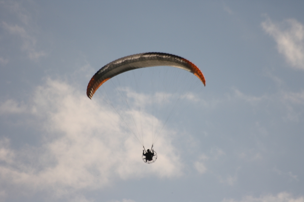
Gliding
Staffordshire Gliding Club - Seighford Airfield offer -
1. Half-day course consisting of 3 aerotow flights or an equivalent number of winch flights lasting a total of about one hour in the air.
2. Aerotow launch behind a light aircraft to over 2000’ for a flight lasting about 20 minutes.
3. Winch launch for a flight lasting about 5 minutes. Climbing steeply to about 1000 feet in 30 seconds.
4. “taster session” for groups. They can provide 10-15 of you with a flight on a Wednesday evening in the summer months.
www.staffordshiregliding.co.uk
Horse Rides and Pony Trekking
Northfield Farm at Flash in the Staffordshire Peak District offers Horse Rides, Pony Trekking and Trail Rides
Beaver Hall Equestrian Centre at Bradnop
Ingestre Stables Ingestre nr Stafford, for Hacking on Cannock Chase
Indoor Activities
Fastlane Karting – King Street, Stoke On Trent - Indoor Karting Circuit operate Biz karts for Corporate & Group Parties, and Sprint karts for our arrive & drive sessions, also have Go-Karts for kids
Flip Out Stoke - Opal Way Stone Business Park, Stone – Indoor Play, Trampoline, Adventure and Inflatable Parks
Outdoor Activities
Adam Evans is a professional outdoor instructor based in the UK’S Peak District, provides high end tailor made courses and often ‘one to one’ coaching and guiding in the outdoors.
Peak District Hang Gliding Centre Experience the exhilaration of free flight as you learn to fly safely with the longest established BHPA registered school
Stanley Head Outdoor Education Centre is owned and run by Stoke-on-Trent City Council for schools, but it is also offer a wide range of options for adult parties (including Hen and Stag parties)
Skiing
Stoke Ski Centre Dry ski slope at at Festival Park, open practice sessions, Ski and Snowboard lessons
North Staffs Ski Club based at Kidsgrove Ski Centre in Bathpool Park give basic lessons for beginners and improver or refresher lessons for experienced or returning skiers on a dry slope
Virtual Reality Experience
Gamegrid formerly XP-VR – Staffordshire's premier virtual reality experience and the only attraction of its kind in the region - 62-64 Piccadilly, located in the Cultural Quarter of Hanley
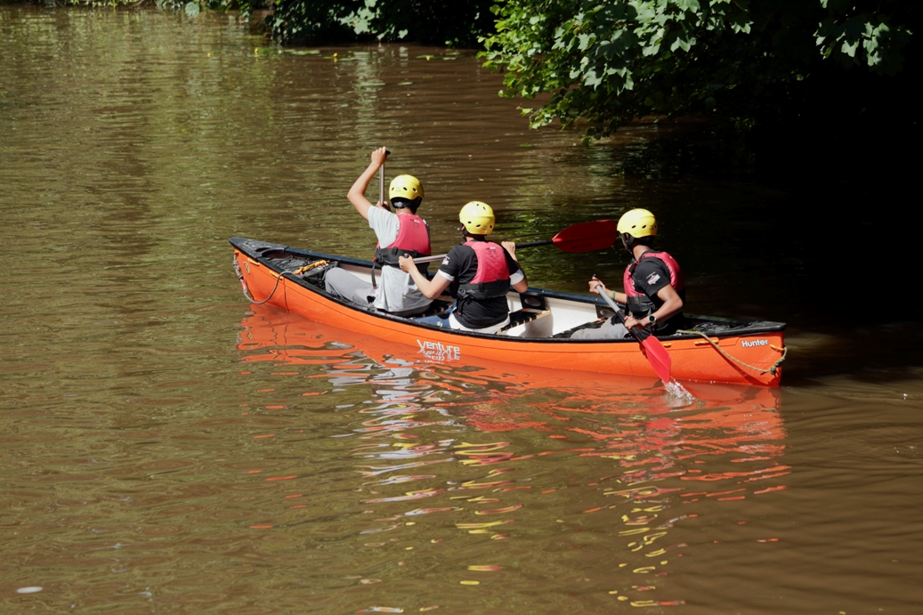
Watersports
Tittesworth Water Sports and Activity Centre – British Canoeing Accredited Centre with Stand Up Paddleboarding (SUP) and Sailing
North Staffs Sailing Club – members club based at Stanley Pool – RYA affiliated
Potteries Paddlers – a multi-disciplined, inclusive, canoe and kayak club based at Rudyard Lake
Trentham Canoe Club – one of the largest canoe clubs in Staffordshire offering opportunities for children and adults of all abilities in fun, recreational canoeing and competitive kayaking – based in Trentham Gardens Lake
There is also the Stoke-on-Trent's Heritage Canoe Trail - click here to download the Trail PDF from britishcanoeing.org.uk

Walking - Walking routes
Long Distance routes
Gritstone Trail – 35 miles – between Disley, Manchester and Kidsgrove, Stoke on Trent. ![]()
Sabrina Way – Bridleway – 203 miles – between Great Barrington, Derbyshire and Hartington, Worcestershire – runs through Dimmingsdale in the Alton Valley a hidden treasure below Alton Towers, there is an excellent Tea Room and Forestry Commission car park see www.forestry.gov.uk/forestry/englandstaffordshirenoforestdimmingsdale
see ![]() and
and ![]()
The Two Saints Way – 92 miles – recreated pilgrimage route between the cathedral cities of Chester and Lichfield see ![]()
The Staffordshire Way – 92 miles from Mow Cop to Kinver Edge, from Mow Cop at the north end of Stoke on Trent it works its way down through North Staffordshire linking many places of interest and attractions.
From Mow Cop it follows Congleton Edge to the top of The Cloud giving views across Cheshire before it drops down and towards Rushton Spencer where it follows an ols railway track to Rudyard Lake, it then follows the Churnet Valley around Leek, passes Deep Hayes Country Park, along the Cauldon Canal to Cheddleton, through Hawksmoor Woods at Oakamoor on to Alton and on in to East Staffordshire at Rocester (Roman) and home to JCB, on to Uttoxeter via Abbots Bromley, Blithfield Reservoir, the outskirts of Rugeley to Great Haywood & Shugborough passing Stafford and on to Penkridge and South Staffordshire.
download a leaflet on The Staffordshire Way from our archive ![]()
Shorter Walks
Dimmingsdale in the Alton Valley (see Sabrina Way above)
Download a 'Staffordshire Moorlands D.C.' published walk leaflet for Furnace Forest walk - 4 miles around Dimmingsdale Alton - ![]()
and ![]() Take a look at our Oakamoor, Dimmingsdale and Alton photo album on Flickr -
www.flickr.com/photos/visit-north-staffordshire...
Take a look at our Oakamoor, Dimmingsdale and Alton photo album on Flickr -
www.flickr.com/photos/visit-north-staffordshire...
Saltersford Lane Circular Walk 5 miles – “This circular walk between the villages of Alton and Denstone is as rich in history as it is in natural beauty. The walk follows the River Churnet and the routes of an old canal and railway to Denstone, before returning to Alton across the hilltops along the ancient Saltersford Lane “ the walk is a nice extension to a walk around Dimmingsdale & Alton (see above), in parts it follows a section of the Staffordshire Way - this is a download from Staffordshire County Council – ![]()
Oakamoor (car park) – take the cycle path along the Alton Valley at the 1st Stone Bridge exit cross the bridge and the path brings you to Dimmingsdale (see above) or continue and exit after the old station taking the road to the right up to Alton Village (left and its Alton Towers) and return the same way or take the lane past the Dimmingsdale car park back to Oakamoor – There are also woodland walks in the NT Hawksmoor see www.nationaltrust.org.uk/hawksmoor which is at the top of the hill from Oakamoor
Oakamoor and Whiston Circular Walk – 8 miles – this is a download from Staffordshire County Council – “This walk around the Churnet valley begins in Oakamoor, follows Cotton Dell upstream to a nature reserve, then climbs up through woodland and over the hill tops to Whiston. From there the walk crosses the valley and passes through the National Trust's woods at Hawksmoor before returning to Oakamoor.” ![]()
Rudyard Lake – there is a car park at the miniature railway station see www.rlsr.org and this also sits on the cycle trail which runs from the lake side to Leek see www.cycle-route.com/routes/Rudyard_Reservoir-Cycle-Route-1178.html There is a circular walk around the lake see www.rudyardlake.com/walking
Download a 'Staffordshire Moorlands D.C.' published walk leaflet from our archive - ![]() also see
also see ![]()
Take a look at our Rudyard Lake photo album on Flickr -
www.flickr.com/photos/visit-north-staffordshire...
www.rlsr.org
Manifold Valley see the National Trust website - a circular walk from the stone-built village of Wetton in the Peak District National Park. Explore Thor’s Cave and then continue down to Ilam Park, before returning along the opposite side of the River Manifold. Manifold Valley Walk
www.peakdistrictcycling.co.uk/manifold-trail/
- download a map produced by the Peak National Park ![]()
Take a look at our Manifold Valley photo album on Flickr -
www.flickr.com/photos/visit-north-staffordshire...
Tittesworth Reservoir Walks – You can enjoy spectacular views of The Roaches as you walk the five mile long trail or take the shorter 1.5 mile trail for those wanting a more gentle stroll – see www.stwater.co.uk/my-severn-trent/our-visitor-sites/tittleswort-water/ also see ![]()
Biddulph Valley Way – an easy, level walk is 3.2km/2 miles long, however the Biddulph Valley Way continues for a further 4 ½ miles through Staffordshire. - Download this 'Cheshire East C.C.' published walk - ![]()
Brown Edge Green Vale – The route is approximately 6 miles following the high ground which runs north through Brown Edge, down the green vale of the Head of Trent to Norton Green and returns along the Caldon Canal to Stockton Brook and then back to Brown Edge
Download this 'Staffordshire Moorlands D.C.' published walk leaflet - ![]()
Caldon Connections – A walk around Froghall - The walk takes you north of Froghall and Foxt into some beautiful wooded areas. It is approximately 4 miles and you should allow 2-2 ½ hours to enjoy the scenery.
Download this 'Staffordshire Moorlands D.C.' published walk leaflet - ![]()
Leek and the Caldon Canal via Ladderedge Country Park - This walk is 3 miles long and follows mainly level ground along the canal, with some steep slopes up and down within the Country Park. Allow 2-2 ½ hours to enjoy the walk.
Download this 'Staffordshire Moorlands D.C.' published walk leaflet - ![]()
Styles in Stone - a walk east from Cheddleton - The walk is about 6 miles long, taking the walker through the Coombes Valley Nature Reserve to the outskirts of Ipstones
Download this 'Staffordshire Moorlands D.C.' published walk leaflet - ![]()
Deep Hayes Circular Walk 8 miles – The walk follows the Caldon Canal from the Deep Hayes Country Park to Cheddleton (part of the Staffordshire Way) then up through the village and on towards Stanley Village & Stanley Pool then over the hill and back down to the canal for the return (some may find a small addition of interest, at Cheddleton if you continue along the canal for half a mile you will reach the Churnet Valley Railway Station, a heritage railway with steam and diesel locomotives, this is their base so workshops, and shunting yards as well as the picturesque little station, and further along the canal is the Consall Nature Park - see above)- this is a download from Staffordshire County Council – ![]()
Take a look at our Deep Hayes photo album on Flickr -
www.flickr.com/photos/visit-north-staffordshire...
www.staffordshire.gov.uk/...
Three walks from Biddulph Grange Country Park - Bailey’s Wood, Biddulph Park and Biddulph Moor - Allow about 2-2 ½ hours for each walk. Most paths are well-surfaced, but be prepared for some muddy and slippery sections.
Download this 'Staffordshire Moorlands D.C.' published walk leaflet - ![]()
Milford Common Trails – Red, Blue & Green trails are about 2 miles each – Milford Common adjoins the Shugborough Estate (National Trust) which also has a number of walks to enjoy – the common is a mixture of heath, tree plantation and old woodland - this is a download from Staffordshire County Council – ![]()
Shugborough Hall and Sherbrook Valley Circular Walk 8 miles – “Easy paths with slight hills at Milford Common and in the Sherbrook Valley “ the walk takes in river, canal, woodland and heath. It cuts through the Shugborough Estate (National Trust) following a section of the Staffordshire Way – and there are opportunities for diversions to add or shorten the walk - this is a download from Staffordshire County Council – ![]()
Take a look at our Shugborough photo album on Flickr -
www.flickr.com/photos/visit-north-staffordshire...
Canal Walks
Great Haywood (next to Shugborough Estate) canal walks along the Trent and Mersey Canal and the Staffordshire & Worcestershire Canal – the junction at Great Haywood is usually busy with leisure boats and there are a number of residential narrow boats – a circular walk can be made by following the Staffordshire & Worcestershire Canal from the junction to Milford, a short stretch down a lane into Milford and the Main Entrance to the Shugborough Estate, walk along the estate road to the car parks then follow the cycle path to Essex Bridge and turning left along the Trent and Mersey Canal you return to the junction
Download a leaflet by the Canal & River Trust on the Great Haywood Canal Junction and local area from our archive - ![]()
Take a look at our Shugborough photo album on Flickr -
www.flickr.com/photos/visit-north-staffordshire...
Froghall Wharf – there is a car park and Hetty’s Tea Room – see hettysteashop.co.uk
From the basin walk along the Caldon Canal for a couple of miles and you will arrive in the Consall Valley, it has a nature reserve, very small railway station (Churnet Valley Railway) and most importantly a pub, follow the canal another mile or so and reach the main station, tea room and riverside pub! To return to Froghall Wharf simply retrace your steps or take Steam or Diesel Train back to Kingsley and Froghall Station, it’s just about a 10 minutes walk back to Froghall Wharf car park and the Tea Room – see www.churnet-valley-railway.co.uk
Barlaston – Downs and Canal circular walk- there is a small car park in Barlaston Village and a car park at the National Trust Downs Banks – the walk takes about 2 hours some hills – the walk follows the lane from the Downs Banks Car Park (turn right at the exit) down to the ford (there is a foot bridge) and follow this quiet lane for about a mile until you reach the canal – turn right and follow the towpath until you reach the Plume of Feathers (Neil Morrissey) (www.plumeoffeathersbarlaston.co.uk), exit through the car park go over the bridge cross the railway and follow the road up the hill to the village green take the right turn past the small car park and take the kissing gate at the entrance to The Upper House Hotel (www.theupperhouse.com) and follow the path through the next gate across the field and at the next gate you enter The Downs follow any of the paths down the valley and work your way back to the car park.
Take a look at our Downs Banks and Barlaston photo album on Flickr -
www.flickr.com/photos/visit-north-staffordshire...
Stoke on Trent – Through much of the city you will not be far from a canal, there are a number of places in the city where you can park and join the canal for a wander –
Hanley Park (just a short walk from the City Centre, commercial and cultural quarters) it is a Grand Victorian Park, Gardens, Lake, play area, sports etc with the Caldon Canal running through the centre – from here its not too far to walk to the junction of the Trent and Mersey and Caldon Canal, just a little further on is the Etruria Industrial Museum and Heritage Centre (well worth a visit especially when in Steam)
Etruria Industrial Museum and Heritage Centre, car park etc, from here you could walk up to Hanley Park (see above) or walk in the other direction to the Festival Park Marina – this is part of the Entertainment and Retail Park which was part of the legacy from the National Garden Festival in 1986
From Festival Park Marina it is a gentle walk to Middleport – past the Middleport Pottery (used in the Pottery Throw Down programmes) and then on to Westport Lake, nature reserve, visitor centre, car parks etc see www.staffs-wildlife.org.uk/visitor-centres/westport-lake-visitor-centre
For Walks and Rides in the adjoining Peak District area see the Peak District – Peak and Moor website
